A map of the southern hemi-sphere ...
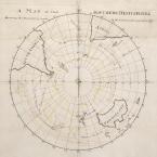
A map of the southern hemi-sphere shewing the discoveries made in the Southern Ocean up to 1770
1772
by James Cook
manuscript (hand-drawn) map
acquired 1922
Safe 1/82
So this map was prepared by Captain James Cook in 1772. It's a very significant point in time in the history of navigation in the southern hemisphere, because Cook has just finished his first voyage of exploration in the southern hemisphere, his voyage aboard the Endeavour, where he ventured into the Pacific Ocean, observed the transit of Venus, but under secret instructions, he was also required to find any evidence of a great southern land, to determine whether such a land mass existed, and if so, to claim it in the name of Great Britain. But because he hadn't found this great southern land, he was really very keen to return to the region.
So this map was prepared in 1772 by Cook. It includes a yellow track which is his proposed route, and in accompanying notes, he talks about the fact that the Southern Ocean really hadn't been fully explored beyond latitude 40 degrees south, which incidentally is where Tasmania or Bass Strait sits. He wanted to circumnavigate the globe in these waters. He also envisaged that during the winter months, he understood that he wouldn't have been able to stay down in the high southern latitudes, so he had deliberately planned a rendezvous with his other ship to go to New Zealand and then into the Pacific, so that the men could have a break from the relentless voyaging in the high southern latitudes, but also to take the opportunity during the colder months to be in the warmer waters where he could do more charting and navigating through the Pacific.
And one of the things to note is that Cook marked several tracks of ships that had previously sailed in these latitudes; Tasman in 1642 and Bougainville in 1767, Captain Samuel Wallis aboard the Dolphin in 1766 to 1768. He marked the capes, the Cape Horne of South America, the Cape of Good Hope off Southern Africa. He had the outline of New Holland, and of course, New Zealand. But it shows that there's a void, and of course, that is because at that time, there was really no knowledge of what lay in these latitudes. He wasn't imagining what might be there. It's the map of someone who was very practical and prosaic. He simply was stating, through his map, exactly what he wanted to achieve, setting out to try to put the southern hemisphere, and particularly the Southern Ocean, onto a map.
A great void
In sailing south from the Cape of Good Hope, Cook began to encounter the challenges of the Southern Ocean. He was entering the area beyond Latitude 40 degrees south, waters that were virtually unchartered. He recorded a sudden dramatic drop in temperature and most of the animals on board that he'd brought on board at Cape Town to be eaten by the crew, died of the cold. He was, I think, realising that this voyage was going to be extremely challenging, and in this region, there's a lot of fog. There's also a lot of snow, freezing conditions, and the beginnings of icebergs floating into the path, really, of his ships.
The other problem was that the rigging and sails would freeze over with the ice, and the sailors of course that were required to climb into the rigging would often have cut hands, and in fact, there were quite a number of deaths as sailors would fall to their death from the ship. So when he started to encounter sea ice further south, he realised the incredible danger of having his ship surrounded by sea ice and crushed.
The thing that he doesn't show of course here, as he couldn't have possibly known, was that he would end up being blocked by large, floating areas of ice shelf. So he navigated back and forth trying to find his way through that, and in the fog, he lost sight of the Adventure. Now, the captains of the two ships had agreed to rendezvous in New Zealand if they did get parted in this vast ocean, and at that point, the Adventure headed north to New Zealand, and Cook remained for a little longer, venturing back and forth along the ice edge, trying to find his way through.
Freezing conditions
The challenges of this voyage, whilst immense, didn't prevent Cook from actually achieving a great deal. What he said in his notes accompanying this map was that he wanted to basically ensure that he had explored the Southern Ocean to the fullest extent that he could. From Cook's perspective, that was his mission. He was absolutely committed to this voyage. He managed to cross the Antarctic Circle and he was the first navigator to do so, and indeed, he crossed it three times in all, and he reached as far south as latitude 71 degrees.
The men, whilst they did suffer enormously from dampness and wet clothes, and apparently, Cook himself had rheumatism for a while, they suffered enormously in the conditions. But they persevered and what they really did was to redraw the world map, really put paid to the myth that had been circulating for centuries that this region did not have a massive land mass that counterbalanced the north.
Now, I should say that having crossed the Antarctic Circle, he didn't actually sight land. He could only speculate that it was a land that wouldn't be habitable and no other explorer, incidentally, would reach that far south, that latitude, for another half century, until the 1820s really when Thaddeus Bellingshausen, the Russian navigator, crossed the Antarctic Circle, and in fact, was one of the first to recording sighting the continent itself, although the first sighting is always controversial. But I think it's fair to say that Cook was well ahead of his time in being in these very high southern latitudes.
Ahead of his time
In the wake of this voyage, Cook's reports to the British admiralty, which were published shortly after his return, alerted a number of commercial interests in the northern hemisphere to the fact that the Southern Ocean, whilst it was a difficult place to navigate, it was navigable and that there were a lot of whales and seals in this region. Now, at that time, whaling and sealing was being carried out around the Arctic, but a lot of those areas were being fished out and these reports drew the interests of a lot of private sealing gangs who sailed to the Southern Ocean in search of new fishing grounds for the sealing, and ultimately for whaling as well.
So whilst we talk about this voyage as being one of exploration, it had huge ramifications for the way in which the Southern Ocean would ultimately become an area for further exploration and exploitation. It also, of course, opened the way ultimately to Antarctic exploration and colonisation in some of the high southern latitudes.
Exploration, exploitation