Southern star chart
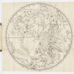
Southern star chart
from Cartes du ciel reduites en quatre tables, contenant toutes les constellations,
1679
by Augustus Royer
publisher: Augustus Royer, Paris
engraved print in bound volume
acquired 2019
MRB/302
Well, traditional Pacific navigating is finding your way. We call it wayfinding. So what it means is when you're out in the middle of the ocean, there aren't too many clues. If you don't have instruments, then you have to be able to learn to use the environment that you're in to give you the clues to find direction and to follow certain pathways.
So the celestial bodies are the first of those, so the sun. We know the path of the sun. We use the moon in a similar way, although the moon generally tends to tell us more about what the tides and the weather and all that is going to be like. Then in the stars of course; so we've mapped the heavens. We have, I suppose, different what we call huinga fetū which are constellations, which are patterns that we recognise for our storytelling. We have birds and whales and kites. We have sails, great fish. Then we've got small fish and lots of fish [laughs].
So we've developed what we call a star compass or an Ātea a Rangi, and star paths, they're stars that fall on our star compass the same place. They rise at the same place and so you can see their path through the heavens and if you know the stars that went before them, you can see a definite line of progression back to where they rose. Then we have star lines. We use that type of phenomenon to help us find land to maintain direction with the stars lined in certain ways. We can find the south celestial poles and we can use that to orientate our waka to sail in any direction.
All those thousands of years ago when people were looking up into the heavens because they never had TV, the stars were an easy way of recording your histories and your stories and the Greeks and the Romans did it really well. You probably go back to the Egyptians and even before them, the Phoenicians, those guys. They would've all been stargazing. Our ancestors did it as well. So the stars have helped people cross deserts, cross continents, cross oceans.
Wayfinding
But the thing about our voyaging is we don't pinpoint an exact point. If we're going up to an island group, we target the island group. And so, we maintain as much as accuracy as we can sailing in one direction, and when we get close, we do a whole bunch of other things that help us to find the land. There's the height of the island that probably expands out to about 30 miles either side of the island. You've got a 60-mile target of sight, so that's not very big after 2,000 miles is it?
So then you go out to cloud cover. So you might be able to see those clouds maybe from about 40, 50 miles, so you've got about a 100-mile target, if you're able to recognise those things. Then you have the birds. Different types of birds will fly out at certain times a year, and they'll fly out anything from between 70 and maybe 100 miles. So you end up having a bigger target.
Now, if you've got an island group, then you've got a whole bunch of islands that expand that even more, and so the target becomes an island group. I might be going say to Rarotonga, but I might end up on Moki, because that island is the one that we ended up being closest to when we saw the signs. Then we landed there and we say, "Hey, bro, where's Rarotonga?" [Laughs] And they go, "That way," and we go, "OK, we're going. See you."
Target practice
When we voyage to somewhere, we say, "When we pulled this island out of the ocean ..." it's like pulling a fish up. So when I learnt how to pull Hawaii out of the ocean, the Southern Cross was the sign that I look for. When you get up to the latitude of Hawaii, then when the Southern Cross is its own height about the horizon, then we're in the latitude of Hawaii. That's a very old sign for determining where that island is. So the pointers in the Southern Cross are really important down here for us. When the Southern Cross comes down to its lowest point in the sky, we call that star Rēhua which is right now Pleiades disappears and we won't see it again until mid-June, or early-June. So when we say Matariki is first seen and Rēhua rests just above the western horizon, we start planning celebrations for our new year. But Matariki is that defining cluster of stars that helps us to find the time to celebrate.
The Southern Cross
Our ancestors, they left South East Asia and they have lots of islands that they were able to populate, and then they eventually got to places where distances became a little further, and so their technology grew with them. And their knowledge of finding direction was most needed when they had to go out of sight of land. And so, those distances got further and further apart, and I think the furthest distance was probably from Solomon Islands through to Fiji, which is about 380, 400 miles, and it's a five-day trip, so you need to be more sure of direction determination. And you learn things about the resources you need to actually cross a wider expanse of ocean.
The reality of Aotearoa is that it was the last major landform to be populated by humanity. Our people arriving here were the first to come to the last place on the planet to be discovered. My teacher came from Micronesia and he used to say things along the lines of, "What's a Polynesian? What's a Micronesian?" Hey, not us that draws the line. It's the historians that want to categorise us and separate us. We're one people. We're Pacific people, because I have people say to me things like, "That knowledge isn't yours," and I said, "Actually it is. Our ancestors came through that way and those people that live there today are the ones that never carried on," but they still had the knowledge, and they still built on that knowledge, and that knowledge has a genealogy that goes back 3,000 years.
One Pacific people
In the Argos, it just so happens that we have two sails to a Waka. There's the diamond cross which is a diamond shape. We call that kaipātiki. So kaipātiki is one of the sails of one our waka that we call Te Waka-o-Tamarereti. And that shape there though talks to us about food. The pātiki shape, the pātiki is a flounder, and so the shape of the diamond is for us the shape of the flounder, so it just means "plentiful food". And the other shape is the false cross, which is a kite shape, much like the Southern Cross, only bigger and doesn't have pointers. And that one is called Pīawai. And those two make up two sails of a waka.
So what happens is when Scorpio comes down and Antares rests on the horizon, the whole waka is formed above the southern horizon from southwest all the way around to Matariki, who's rising in the northeast. And so, the shape of Scorpio becomes what we call a Tau Ihu which is the prow of a waka. And the shape of Orion, when it rises above the horizon – those three stars and Orion, Tautoru, that becomes the stern post of a waka.
And in between, you have the Southern Cross at its lowest point in the sky becomes what's called a Punga which is an anchor stone and the two pointers are the ropes that tie it to the side of the canoe. Of course, you have the two sails and then you have Atutahi which I said earlier which is Canopus, eldest of all the stars. He becomes what we call the Kaihotu which is the captain of the waka. So he's the leader and Takurua which is Sirius, is the brightest star in the sky. So we say that's Whetumarama. So what that means is that's an enlightening star.
So because it's the brightest star in the sky, it's the star of knowledge, and it sits just below the taurapa, and if you know how we build our war canoes, we always put our tohunga who is the priest on that waka, the man that holds all the knowledge, he sits just below that taurapa, so Takurua becomes that guy, the holder of knowledge.
And then the three stars which are in the taurapa, which in the stern post which goes up into the heavens, that's the pathway into the heavens, and part of our stories that we tell is how one of our gods climbed up through the heavens to receive the three baskets of knowledge. So those three stars in a row become those three baskets of knowledge, and they're there being held by the tohunga, by that priest, and he shares that knowledge to help guide the waka across the ocean. So all of those stars there are pretty much represented in this map that you've given me. So we see things differently, although the coincidence of the sails in the Argos are pretty cool.
Waka (war canoe) in the sky